
Topcon LN-150
Layout Navigator
Easy, Speedy and Convenient The Ultimate Solution for Stake-out Operations

- Small & Light weight
- Easy Installation
- Brightness & Visible guide light for guidance
- Oprated by mobile phone and tablet
- Ultra-high speed & Quick response
“Revolutionary Stake-out”
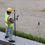
Very useful for Civil Engineers, Site Engineers and for any construction site.
Easy!

Easy one-button self-leveling setup. No need to check the bubble level for the installation.
Speedy!
The Layout Navigator automatically turns and faces to the next stake-out point with the touch on your mobile phone. No need to turn the Layout Navigator by hand.
Convenient!

Guide light can be used to easily teach stake-out point. Precise locations are displayed on the mobile phone, so there is no need to look through the telescope repeatly.
Basic Features Self Leveling
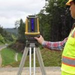
After the Power is turned ON, the instrument automatically starts leveling itself, With internal precise tilt sensor and motorized mechanism. Conventional way for leveling the instrument with foot screws were totally eliminated.
Quick Response
On-screen prism location in real time thanks to high speed data updates at 20 times per second.
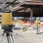
Works anywhere

260m diameter range, Maximum vertical angle is +55 degree. It covers the construction site to do stake out works.
Easy guidance
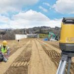
After identifying the stake-out point, Layout Navigator will guide you in the rough direction with guide light.
Rugged and Compact design
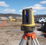
- Small and light weight
- Waterproof and dustproof design
- Easy to carry
- Completely sealed housing
Operation with mobile phone
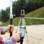
LN-150 can be easily operated with mobile phone
Top Layout

Basic 3D design data stake-out and topo application Freeware downloadable from Google Play!
MAGNET Construct
3D LAYOUT IN THE PALM OF YOUR HAND
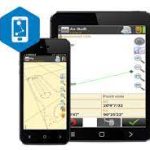
- Mobile app for Android and Ios handheld devices
- Built to control robotic total stations, GNSS receivers and Layout navigator
- Longlink technology for a GNSS rover and base connection
- Simple, easy-to-use interface
- Change language and terminology within seconds
- Share files directly via email or through MAGNET Enterprise
- Secure data transfer, both to and from the field
Specification
Model
- Model
- LN-150
Measuring Range
- Distance
- 0.9 – 130m (Range Note 1)
- Vertical Range
- +55° to -30°
Measurement Accuracy
- Distance Accuracy
- (3.0 + 2ppm x D) mm
- Angle Accuracy
- 5″
Auto Leveling
- Leveling Range
- +/- 3 degree
- Inclination Compensation Method
- Hydraulic dual-axis inclination sensors
- Working Range
- +/- 6′
Motor
- Motion Range
- 360° (Horizontal)
- Maximum Rotation Speed
- 60° / second (10 rpm)
Guide Light
- Light Source
- LED (Red 626nm / Green 524nm)
- Visible Range
- Horizontal > 8° (7m @ 50m distance)
Laser Plummet
- Light Source (Laser Diode)
- Class 2
- Light Source (General)
- LED 635nm
Communication
- W-LAN
- 802.11 n/b/g, 100m
- Bluetooth Class
- 1
- Usable Range for Bluetooth
- to 130m (Range Note 2 & 3)
Power Supply
- Standard Battery
- BDC72 Lithium-ion battery
- Operating Time
- Approx. 5 hours (continuous use, at 20°C)
Dimensions and Weight
- Dimension (W x D x H)
- 185 (W) x 198 (D) x 322 (H) mm
- Weight
- Approx. 4 kg (including battery BDC72)
Environmental Resistance
- Operating Temperature
- -20 to +50°C (no condensation)
- Storage Temperature
- -30 to +60°C (no condensation)
- Dustproof / Waterproof
- IP65
Notes
- Range Note 1
- When prism ATP2 or ATP2S is used. Ambient condition: not under severe weather of Rain / Fog / Heat Shimmer.
- Range Note 2
- No obstacles, few vehicles or sources of radio emissions/interference in the near vicinity of the instrument, no rain.
- Range Note 3
- Usage range could be shorter depending on specifications of Bluetooth device to communicate.
Brochure
Video