Features
</li>
<li>Dual SIM Card Support</li>
</ul>
<h3>Compact. Rugged. Advanced. Affordable.</h3>
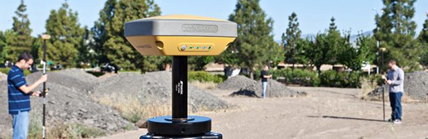
<p>Providing leading edge technology in a smart, rugged design, the new HiPer SR provides superior performance at an affordable price. The compact, integrated receiver design includes the 226-channel Vanguard GNSS technology with Universal Tracking, industry leading Fence Antenna™, sealed long-life power supply, and memory storage.</p>
<p>The HiPer SR comprises two different communication options including Topcon’s innovative LongLink™ communication technology and integrated cellular module (optional).</p>
<p>With the HiPer SR, now made in the USA, you don’t have to sacrifice durability and performance to have a versatile 3D job site system. HiPer SR – a compact lightweight receiver that is built to take the most intense environmental conditions and job site punishment.</p>
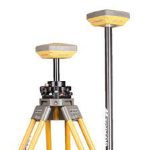
<p>In addition to ruggedness, the HiPer SR is the most versatile, configurable, compact receiver system available. Use just two units in many configurations, depending on the demands of the project site. Use as a job site base and rover with interference-free LongLink communication up to 300m or base and rover with MAGNET Relay cellular communication RTK up to 35km baselines.</p>
<p>A pair of HiPer SR receivers can also be used with internal SIM cards as network rovers with Topcon TopNETlive GNSS Reference Network, two network rovers with internet capable field controllers, two dual frequency static receivers, or in conjunction with a robotic instrument for Hybrid Positioning. All these configurations from just two receivers that can fit into any laptop carrying bag.</p>
<h3>226-Channel Vanguard Technology™ with Universal Tracking</h3>
<p> <img decoding=)
Topcon’s exclusive channel tracking technology provides unmatched GNSS signal flexibility and expandability.
Integrated Cellular Module (Optional)
When cellular coverage is available, the HiPer SR is versatile enough for short or long range. The HiPer SR as base and rover is a simple way to do RTK through MAGNET Relay.
Smart Design
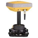
HiPer SR brings an innovative combination of compact, lightweight, environmentally sealed, rugged and cable free design. It is guaranteed to survive a 2m on the pole drop to concrete.
Fence Antenna™
When compared to any other RTK receiver available today, the Fence Antenna™ technology provides more robust, cleaner signal tracking which means unparalleled results.
MAGNET™ Relay Service

In cellular mode, MAGNET Relay RTK service, allows the HiPer SR to be used as a mobile RTK base “relaying” corrections from the base to up to 10 rovers, through the MAGNET Enterprise “cloud.” MAGNET Relay is an RTK forwarding service that allows users to broadcast in-field base stations to their company MAGNET Enterprise cloud for the purpose of distributing the base station RTK messages to their own rover receivers.
LONGLINK
Topcon’s exclusive LongLink™ RTK technology provides the perfect short range RTK communication 1,000+ ft. (300+m) from the base station. With the HiPer SR, enjoy reliable, interference free RTK base-rover communication that doesn’t require an FCC license to operate.
Field
Modern User Interface
MAGNET Field provides a bright, graphical user interface with large touch icons, and bright readable text. The screens not only look good, but provide fast workflows.
Easy to Use
The user interface has been optimized to provide both text and images to easily view data and enter information. Shortcut buttons and fast access tabs provide a very productive interface.
Advanced Calculations
MAGNET Field not only controls the measurements of the instrument but also provides many COGO and adjustment calculations.
TopNET live
RTK Positioning Service
TopNETlive is a subscription based, real-time GNSS Reference Network delivering high quality, GNSS correction data to rovers used for surveying, construction, GIS mapping and agricultural applications. TopNETlive is the fastest growing RTK worldwide network. Visit www.topnetlive.com to view network coverage maps and join TopNETlive
Specification
Tracking
- Number of Channels
- 226-channel Vanguard Technology™ with Universal Tracking Channels
- Signals
- GPS: L1, L2, L2C
GLONASS: L1, L2, L2C
SBAS – QZSS: L1, L2C - Antenna Type
- Integrated Antenna with Fence Antenna™ Technology
Positioning Accuracy
- RTK (L1+L2)
- H: 10 mm + 1.0 ppm, V: 15 mm + 1.0 ppm
H: 3 mm + 0.5 ppm, V: 5 mm + 0.5 ppm - Fast Static (L1+L2)
- H: 3 mm + 0.5 ppm
V: 5 mm + 0.5 ppm - DGPS
- H: 0.4 m, V: 0.6 m
- SBAS
- H: 1.0 m, V: 1.5 m
Communication
- RTK Broadcast
- LongLink™ 300m+ Range
Up to 3 simultaneous rovers - I/O Communications
- Bluetooth®, Serial, USB
- Cellular
- Integrated HSPA+ (Optional)
- Dual Sim Card
- available
Data and Memory
- Memory
- 2GB internal
- Data Update/Output Rate
- Up to 10Hz
- Real Time Data Output
- TPS, RTCM SC104 v 2.x, 3.x; CMR/CMR+
- ASCII Output
- NMEA 0183 version 2.x and 3.0
Physical
- Dimensions (w x d x h)
- 6 x 6 x 2.5 in.
150 x 150 x 64mm - Weight
- 1.87 lbs. (850g) – Basic
2.04 lbs. (925g) – Cellular - Status Display / Panel
- MINTER
- External Power Connector
- Yes
- Operation Time
- Up to 20 hours
Environmental
- Operating Temperature
- -20ºC to 65ºC
with internal batteries
-40ºC to 65ºC
with external power - Storage Temperature
- -40ºC to 70ºC
- Humidity
- 100%, condensing
- Water / Dustproof
- IP67
Brochure
Video