

HIPER VR Versatile GNSS Receiver
Complete, Cutting-Edge Performance

- Universal Tracking Channels™ for all satellites, signals and constellations
- Field-tested, field-ready IP67 design
- Compact form factor ideal for Millimeter GPS and Hybrid Positioning™
- Revolutionary 9-axis IMU and ultra-compact 3-axis eCompass
Better things in smaller packages

The HiPer VR-K is smaller and lighter, but don’t let its small size fool you. It’s not only packed with the most advanced GNSS technology, it is also built to withstand the harshest field environments. Built with a rugged housing – not weak plastic – it can take the punishment of the job site. Using the Topcon advanced GNSS chipset with Universal Tracking Channels™ technology, the receiver automatically tracks each and every satellite signal above – now and into the future. All signals, all satellites, all constellations — all in a compact, rugged design, with an integrated IMU and eCompass.
TILT™ – Topcon Integrated Leveling Technology
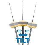
The HiPer VR-K incorporates a revolutionary 9-axis inertial measurement unit (IMU) and an ultra-compact 3-axis eCompass. This advanced technology compensates for mis-leveled field measurements out of plumb by as much as 15 degrees Awkward shots on steep slopes or hard to reach spots are now a breeze with TILT.
Integrated radio and modem options

- 400 MHz UHF TX/RX Radio 1
- License-free 900 MHz radio, FH915 protocol
L Band Ready Technology
L Band ready to receive advanced GNSS corrections data set globally.
Highly configurable
Designed to grow with you, unique electronic option files empower you to activate available features instantly.
Future proof
The Topcon full wave antenna tracks all GNSS signals currently available and is designed to track the constellations and signals of tomorrow.
Specification
GNSS Tracking
- Channel Count
- 226 with Topcon’s patented Universal Tracking Channels™ technology
Signal
- GPS Signals
- L1 C/A, L1C† L2C, L2P(Y), L5 †L1C when signal available.
- GLONASS
- L1 C/A, L1P, L2C/A, L2P, L3C‡ ‡L3C when signal available.
- Galileo
- E1/E5a/E5b/Alt-BOC
- BeiDou/BDS
- B1, B2
- IRNSS
- L5
- SBAS
- WAAS, EGNOS, MSAS, GAGAN (L1/L5§) §L5 when signal available.
- L-band
- TopNET Global D & C Corrections services
- QZSS
- L1 C/A, L1C, L1-SAIF, L2C, L5
Positioning Performance
- Static/ Fast Static
- H: 3 mm + 0.4 ppm
V: 5 mm + 0.5 ppm* - RTK
- H: 5 mm + 0.5 ppm
V: 10 mm + 0.8 ppm - RTK, TILT Compensated
- H: 1.3 mm/°Tilt; Tilt ≤ 10°
V: 1.8 mm/°Tilt; Tilt > 10°
Maximum recommended angle for tilt compensation is 15°.** - DGPS
- 0.25 m HRMS
- L-Band, D Corrections Service
- H: < 0.1 m (95%), V: < 0.2 m (95%)
- Operational Time
- RX mode – 10hr TX mode 1W – 6hr
Use of external 12V battery is recommended when using HiPer VR with internal radio in transmit mode. - Internal Radios
- 425-470 MHz UHF radio
Max Transmit Power: 1W
Range: 5-7 km typical; 15 km in optimal conditions.*** - Memory
- Internal Non-removable 8 GB SDHC
- Environmental
- Ingress Rating – IP67
Operating Temp – ‘-40ºC to 70ºC
Humidity – 100%, condensing
Drop and Topple –
1.0 m drop to concrete.
2.0 m pole drop to concrete. - Dimensions
- 150 x 100 x 150 mm (w x h x d)
- Weight
- <1.15 kg